Researcher measures mighty movement
Kaikōura wasn’t just the most complex earthquake ever recorded, it also moved the ground further than most other known earthquakes, says EQC-funded Victoria University of Wellington student researcher Jesse Kearse.
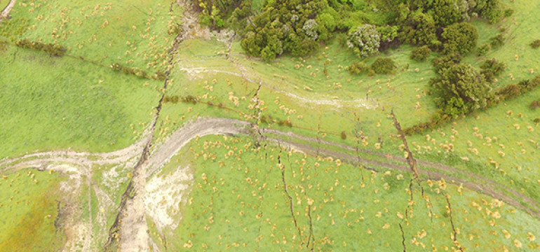
Jesse looked at how the Earth's surface was shifted sideways along the 83 km stretch of the Jordan, Kekerengu, and offshore Needles faults for his Masters degree.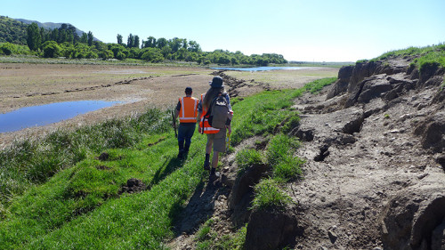
“Of the known earthquakes worldwide, New Zealand has two in the top five for ground rupture movement,” says Jesse.
“The Kekerengu fault moved the land sideways by up to 12 metres and in some places the rupture zone was over 300 metres wide. For a fault rupture around 83 kilometres long, this amount of movement is unusual in world terms, so it tells us we can’t really use global knowledge to define these large New Zealand earthquakes,” he says.
Jesse spent months carefully measuring the ground movement along the main Kekerengu fault, putting together knowledge that earthquake scientists and land planners can use to help understand what might happen to the ground in a future quake.
“Being able to use markers like fence lines and farm tracks was a big advantage in getting solid evidence on how much the land moved along the fault. Fences were simply shunted along with the land they sat on, so we could get exact measures on the movement,” he says.
“The science community also took the opportunity to test out the newest measurement technology, InSAR, which uses satellites to measure what happens on the ground. With our team of geologists actually walking the paddocks with measuring tapes (and other survey gear), we were able to show that the InSAR technology was accurate to within one metre. So in future, scientists will be able to do some of this kind of work from a desk, delivering data and information for emergency managers and landowners much faster.”
EQC’s Dr Richard Smith says the research has great practical application for New Zealand.
“It’s shown us that we can’t use overseas prediction models for what’s actually going to happen on the ground surface, and it gives us valuable data to put into our own New Zealand National Seismic Hazard Model. It builds on the data from GeoNet sensors about what has happened on the land and contributes to a more detailed picture of what the impact of an earthquake is likely to be. The other really useful result of this research is that it effectively gave us a live test of the new InSAR technology, which can also be used to measure other land movements like landslides.”
Jesse says there will still be a place for walking the ground though.
“The fault surface rupture is more of a messy zone than a perfect narrow slice. InSAR can’t, for instance, resolve the details of what happened within that messy rupture zone. To document that kind of detail you need to be on the ground with measuring equipment to see how an earthquake actually breaks up the land, and this is useful information for planners and landowners.”