National Seismic Hazard Model
We’re proud to have worked with GNS Science(external link) and the Ministry of Business Innovation and Employment(external link) to update the National Seismic Hazard Model (NSHM)(external link).
This is the first time it has been updated since 2002 and now incorporates the latest international science, plus data and knowledge from significant earthquakes around Aotearoa New Zealand over the last two decades (including the Canterbury earthquake sequence and the 2016 Kaikōura earthquakes).
The NSHM estimates the likelihood and strength of earthquake shaking in different parts of New Zealand and is widely used by government, industry, reinsurers and insurers to help estimate earthquake risk.
 The NSHM provides critical information for decision making about how buildings are built, where critical infrastructure like roads and rail networks go, plus insurance and civil defence planning.
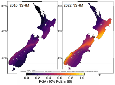
This map (right) shows the comparison of 2010 and 2022 peak ground acceleration (PGA) from earthquake shaking. These results are explained in the NSHM.
See more
See more about the National Seismic Hazard revision programme on the GNS website